 |
 |
|||
|
|
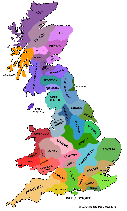
EBK presents a map of Britain as it may have appeared around AD 550. The Saxons settlements expand in East Anglia and the proto-Mercian settlers extend into the Peak District leading to the fall of the British Kingdom there. The beginnings of the Kingdom of Essex are to be seen, North of the Thames. Wessex joins with the Gewissae of the Upper Thames Valley, descendants of Roman mercenaries of Germanic origin [Green]. This divides the Kingdom of the old Atrebatic territory in two, and a new British dynasty probably establishes control of Caer-Baddan (Bath) [Tan]. Glywysing and Gwent are united under King Meurig [Light Red], whilst Rheged is divided amongst heirs [Mint Green/Pale Blue]. A landless son of the British Pennine Dynasty establishes Calchfynedd over the Chiltern Hills [Light Blue]. The Kings of Strathclyde overrun Galloway and force its monarchy to flee to Ynys Manaw (Isle of Man) where they continue to rule a much reduced kingdom [Indigo]. In the confusion, a scion of the House of Ebrauc manages to establish a lordship around Caer-Wenddoleu [Mauve]. Soon afterwards, Strathclyde is divided amongst heirs, producing a kingdom in the old tribal region of the Selgovae (of unknown name) and another, possibly in Galloway [Indigo/Sea Green]. One landless heir invades Gododdin and establishes himself over Din Eityn (Edinburgh) [Purple]. The Scots of Dalriada move up Glen Orchy & Glen Etive and across to Morvern & the Isle of Mull [Orange].
Click through to Britain in AD 575
|
|||
| © Nash Ford Publishing 2003. All Rights Reserved. | ||||


